Bandar Lampung is divided into 13 subdistricts (kecamatan): Kedaton, Rajabasa,
Tanjung Senang, Sukarame, Sukabumi, Kemiling, Tanjung Karang Barat, Tanjung Karang
Pusat, Tanjung Karang Timur, Teluk Betung Barat, Teluk Betung Selatan, Teluk
Betung Utara, Panjang.
Type A climates Bandar
Lampung, while according to agro-climate zone Oldeman (1978), classified as Zone
D3, which means humid throughout the year. Rainfall ranges from 2257-2454 mm / year.
Number of rainy days 76-166 days / year. Ranges from 60-85% humidity, and air
temperature 23-37 ° C. Wind speed ranged from 2.78 to 3.80 knots with the
dominant direction of the West (November-January), North (March-May), East (June-August),
and South (September-October).
In
this city there is a port which
is the length of the import-export
port for the Port Srengsem Lampung and
also the port
for the distribution of the coal traffic from
South Sumatra to
Java. Approximately 92 kilometers south of
Bandar Lampung, there Bakauheni, which is a
port city in the province of Lampung,
precisely at the southern tip of Sumatra
Island. Located at the southern
end of Jalan Raya Lintas Sumatra,
Sumatran port of Bakauheni
connect with Java
via sea transport.
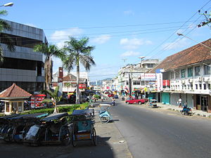
Pictures of Bandar Lampung :


